Požádat u ukázku výstupních dat
a nebo nás rovnou kontaktujte.

Bavory Spring Site Shafts

We created a BIM model of the Bavory Spring Site shafts.
Plocha: 140 m2
For more information, scroll

Detailed description

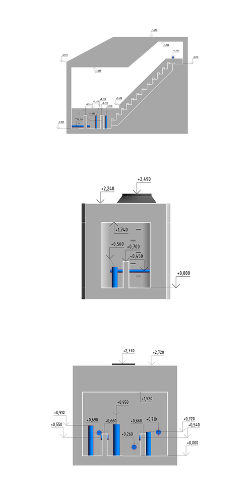
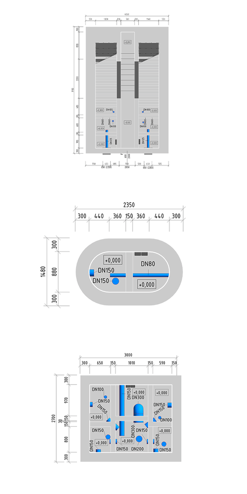
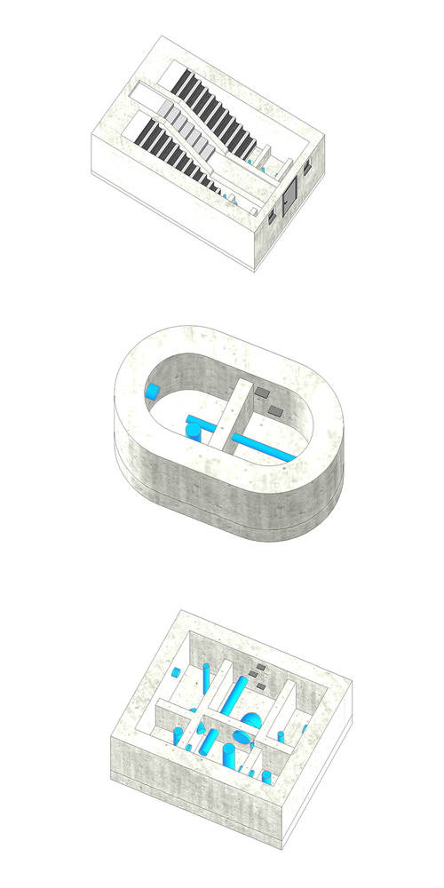
The scope of the project involved surveying underground water supply shafts in an inaccessible area of the spring site and preparing documentation for them, including BIM models at LOD100. Specifically, this involved surveying and modeling visible structural elements, including piping. The data collection conditions—the internal complexity of the structures, limited space, and difficult access—were ideal for using the GEOSLAM ZEB REVO RT handheld mobile scanner.

3D Modeling and BIM

The modeling work was performed in Autodesk Revit. The point clouds collected by the scanner and processed in GeoSLAM Hub software served as the basis for the work. The completed shaft models serve as data for designers and as detailed electronic documentation—a digital twin of the structures.

Output data formats: RVT, DWG

Objectives and Benefits

Our goal is to collect data and create 3D models of existing buildings in accordance with BIM standards, at the level of detail specified by the client. We prepare data for design firms—direct integration with the model is achieved using native formats or, if necessary, by exporting to another required format.

Graphical Benefits

  • Visibility of structures and internal installations (graphical and descriptive information)
  • Better orientation and visualization for the client (handling changes to the project)
  • Ability to generate 2D drawing documentation
  • Additional modifications and updates to the model are automatically reflected in all drawings
  • Easy comparison of the actual state against the project

Non-graphical advantages

  • Ability to connect to building management systems
  • Modelled objects reported automatically (count, dimensions, etc.)
  • Simple and fast tabular reports and statistics

Technologies used

Geoslam ZEB REVO RT

Mobile laser scanning system for use especially in the building interiors. It uses a combination of laser scanning and SLAM (simultaneous localisation and mapping) technologies.
Request a sample of output data

Reference

Site in Velké Meziříčí

We created a BIM model of a construction company’s building complex in Velké Meziříčí.
More information
Plocha: 42 200 m2

Survey of the Velký Blaník Lookout Tower

We have created accurate and detailed documentation of the lookout tower
More information

3D documentation of utility networks by mobile phone

For EG.D we provided 3D data collection in the field at the LV and HV transformer stations.
More information

Schools in Nové Město nad Metují

We have developed a BIM model of 6 buildings of the Secondary Industrial, Vocational and Primary School in Nové Město nad Metují
More information
6143 m2

Case Study from District Court

We have elaborated the as-built documentation of the District Court in Karlovy Vary
More information

Model of villa Strakonice

We created a BIM model of a villa in Raisova Street
More information
200 m2

Residential building in the center of Prague

We mapped a residential building with a floor area of about 2500 m2.
More information
2 500 m2

Pasportization of Čiper's Villa

We prepared a passportisation of Čiper's villa in the form of a BIM model.
More information

Hranice and Jezernice viaducts

We have created 3D visualizations of historical buildings.
More information

3D Model of the Nekmíř Castle

We scanned the Nekmíř Castle using the laser scanning method and made a 3D model.
More information
Area: 790 m2

Railway Station Documentation for BIM Model

Reconstruction of the tracks and platforms at Čachovice railway station.
More information
Area: 63 150 m2

Production and Storage Hall

We created a BIM model of the production and storage hall.
More information
Area: 7 500 m2

Family House

We have created a 3D model of a family house in Ústí nad Labem.
More information
1 100 m2

Passportisation of Bridges and Culverts for the Road ŘSD

We have prepared a passportisation of bridges and culverts in the form of BIM models.
More information

Water Treatment Plant – Vír dam

We have created a BIM model of the area around the Vir dam.
More information
12 500 m2

Company Headquarters

We have created a BIM model of the HRDLIČKA headquarters premises in Stodůlky, Prague.
More information
Area: 5 500 m2

Contact Us

Not sure which service is ideal for you? Ask our experts.

Ing. Miroslava Kubíčková

Expert consultant in the field of mapping, LiDAR, photogrammetry, UAV/UAS, 3D models, and BIM

By submitting the form you agree to data protection (GDPR)

Děkujeme za odeslání, budeme vás kontaktovat.
Něco se pokazilo. Můžete to zkusit prosím znovu?
Follow us